

The transformative power of nature: A new business member profile
Research has long shown that time spent in nature is good for us, body and soul. The American Heart Association, among...


During this challenging time of change for our nation and for our national parks, Friends of the Apostle Islands National Lakeshore wants to shine a bright light – a lighthouse beacon if you will – on this very special place and on the people dedicated to protecting the national lakeshore for future generations. That’s the goal of our series entitled “Love our Lakeshore.” (You can tell us why you Love Our Lakeshore by filling out our simple form at this link.)
In this report we update plans to deploy Wave Watch buoys in the spring of 2025 to improve your safety on the water. We also take a look back at how and why this life-saving initiative began.
Timing is everything when it comes to venturing onto the inland sea we know as Lake Superior. Choose the right time and the right wave and weather conditions and you’ll have a wonderful adventure. Choose the wrong time and you could get into very serious trouble. The Wave Watch buoy system to be deployed this spring is a vital real-time information source designed to help keep you safe. It’s a cooperative effort of the National Park Service, Friends of the Apostle Islands National Lakeshore and the University of Wisconsin – Madison.
University of Wisconsin research scientist Josh Anderson has been part of the water safety initiative from the beginning. He says “the real value is the ability to plan a safe trip and an enjoyable trip. The wave buoys can give you an indication when the lake is flat and calm and perfect, as opposed to when the lake is really rough and dangerous.”
The idea of creating a real-time wave monitoring system started as a response to a series of kayaking deaths in the Apostle Islands National Lakeshore. In 2004, a 23 year old man paddling with his father died of hypothermia after his kayak tipped and filled with water in rough conditions at the mainland sea caves. In 2007, a 55 year old man died of hypothermia after his kayak flipped near the same sandstone cliffs. The victim and another man had paddled to the sea caves in calm conditions but afternoon winds made the return trip to Meyers beach treacherous.
With the prospect of saving lives, partners built and deployed a new wave monitoring system in 2009.

Diagram of original wave monitor system – click to enlarge

Original wave monitor deployment in 2011 – Josh Anderson photo
Coastal engineering specialist Gene Clark with the University of Wisconsin Sea Grant Institute, Park Superintendent Bob Krumenaker, Dr. Chin Wu, professor of civil and environmental engineering at the University of Wisconsin and staff brainstormed on a system that could provide real-time information from the sea caves that could be viewed at Meyers Beach to provide sea kayakers with important information before launching into potentially dangerous conditions.
Early versions included a pyramid-shaped platform submerged near the mainland sea caves. Onboard electronics positioned at the top of a long, submerged pole measured changes in water pressure caused by wave activity on the surface.
Data from the sensor traveled through a very long cable that ran along the lakebed and up a sandstone cliff to a solar-powered modem at the top. The data was relayed by cell phone signal to a receiver and eventually to Meyers Beach and to a website maintained by the University of Wisconsin.
Remote cameras positioned at the top of the cliff provided additional information about the conditions.
Dr. Wu and Gene Clark wrote research proposals that were successfully funded by the National Oceanic and Atmospheric Administration, the Wisconsin Coastal Management Program and Friends of the Apostle Islands, with support by the city of Bayfield.
The National Park Service provided significant in-kind support including launching and retrieving the equipment evey spring and fall when the system was in use.
Julie Van Stappen, the lakeshore’s retired Resource Stewardship Director and liaison for the project says, “Dr. Chin Wu and Josh Anderson did an amazing job developing this system and continuing to improve it as new technological advances have become available. The project has only been possible due to passionate and dedicated partners working together to help improve safety of park visitors.”
Van Stappen says that an unexpected side benefit from the project was the availability of real-time images from the sea caves, not only in the summer but also in the winter to help the park determine ice conditions.
Superintendent Bob Krumenaker said at the time that the cameras were valuable “especially in winter 2014, when record visitation to the ice-covered caves made international news.”
The cameras, available on the WISC Watch website continue to provide invaluable information for both winter and summer conditions.

Chin Wu, Josh Anderson and Karl Carlson set up a new location above the sea caves in 2018 – NPS photo

Snow-covered ice at the mainland sea caves March 11, 2025
In 2015, Wu said, “The goal was to make people using the caves feel safe. It’s been gratifying to be part of a project that’s had an impact and has made a difference.”

solar-powered spotter buoy
Testing of a solar-powered buoy system began in 2018; the system was eventually deployed starting in 2021. Anderson says, “For me, the accuracy of the wave measurements is the most beneficial part of the buoy. It measures the waves directly and accurately, compared to an indirect measurement of pressure changes below the surface.”
Anderson says the satellite technology used to transmit the data to the UW for display on the WISC Watch website is also much more reliable than cellular technology used in the original system.
After two successful seasons, funding sources dried up in 2023 so the buoys were not deployed that summer. Lakeshore visitors lost access to life-saving real-time wave information.
That changed in 2024 when a team deployed the buoys after Friends of the Apostle Islands National Lakeshore agreed fund a public safety service and awareness campaign we call Wave Watch. With donor support, we’re paying the data subscription fees for a minimum of two years. Friends now displays the real time wave and water temperature data on its website. That data, along with historical data, also continues to be available on the existing WISC Watch website.

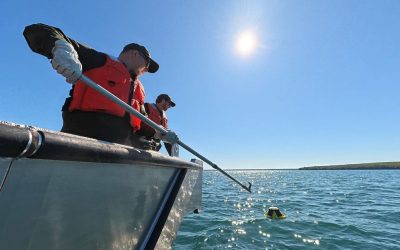
Friends Executive Director Jeff Rennicke holding a yellow buoy as we prepare for deployment in 2024 – Jon Okerstrom photo
Combined, the two websites counted more than 30,000 pageviews during the 2024 summer season. “The website metrics and feedback we’re getting from the boating communities tell us people appreciate the real-time data,” says Friends Executive Director Jeff Rennicke.
“We’ve given away lots of free QR Codes to give people another way to use their phones. to get to the Wave Watch data quickly and easily.” If you don’t have a free cling or sticker for your boat or car yet, you can get one by following this link.
Greg Weiss, owner of Lost Creek Adventures says his guides use and value the Wave Watch system. His Cornucopia-based company has been in business since 2011, offering both day trips and multi-day adventures. Every summer, the guides help more than 6,000 lakeshore visitors experience paddling Lake Superior and exploring the sea caves. He says, “Any data you can get is good. We never rely on just one thing. Different apps and websites display things differently. Having the Wave Watch is super helpful. Our guides will have two screens on their phone: the WINDY weather website and WISC Watch.” (Editor’s note: real-time data is available on both the WISC Watch website and the Friends website.)

Greg Weiss, owner of Lost Creek Adventures
No matter which website you choose, Anderson says the current system of buoys offers real-time measurements that forecast models displayed by other platforms simply cannot replicate. He says that’s important because of how the islands can focus or funnel the wind that blows between them, which directly affects wave conditions.

Josh Anderson, Steve Ballou and Karl Carlson work to retrieve the buoys at the end of the 2024 season – Jon Okerstrom photo
Planning is well under way for the 2025 summer season. The goal is to deploy five buoys before the Memorial Day weekend and the unofficial start of the peak season in the lakeshore. While buoys at the mainland sea caves, at the Stockton Island tombolo and at the north end of Devils Island will be placed near last year’s locations, two others will be moved. Anderson says, “This year, we’ll have two new locations where we’ve never measured waves before. We will be able to validate the models at the new locations and serve new user groups.
We plan to move the Sand Island buoy into a location between Hermit and Basswood Islands and the mainland to sample waves in that area. The long Island buoy will be moved into an area known as “the flats” to better inform the fishing community about that popular area.
Anderson also plans to make adjustments to the rigging that anchors the buoys to the lake bottom, in part to increase buoy visibility and to reduce the chances that the anchor lines will tangle.

Planned 2025 buoy locations – click to enlarge
Despite his involvement in the water safety project for more than a decade, Anderson has not yet experienced paddling the sea caves. He says a 6 or 7 day trip through the islands is on his bucket list. Anderson says being involved in this effort has given him a new appreciation for our national parks and for the Apostle Islands. “It really does mean something to me,” he says. “I think of myself as a homegrown Wisconsin boy. To experience this kind of gem in Wisconsin is really special for me. It’s sparked a love for me and my wife to visit our national parks and experience the natural beauty.”
Friends of the Apostle Islands wishes to thank the University of Wisconsin – Madison, the National Park Service, including project lead Karl Carlson, and our Wave Watch donors for helping to make the lakeshore a much safer place to enjoy. You can join the cause by making a donation. With your support, we will continue offering this vital public safety effort in 2025, and hopefully beyond.


Written by Jon Okerstrom. Jon is a Friends of the Apostle Islands National Lakeshore board member and digital and social media volunteer with a background in digital and television journalism, photography and graphic design.
Share this article…
Research has long shown that time spent in nature is good for us, body and soul. The American Heart Association, among...

Bands of elk are not the only ones to gather in Estes Park, Colorado this autumn. The gateway city to Rocky Mountains...
We saw it in the first hints of crimson and gold in the mainland treeline. We felt it when the water temperature...